Plugin Showcase
Geodesignhub follows Python’s premise of “batteries included”. What does that mean? It means that your projects come with rich, standard functionality that can be utilized without having you having to download various packages or installing software or worrying about software licenses, technical skills etc.
This gives Geodesignhub a head start in many projects because the focus is on the problem at hand and not software requirements or technical skills etc. To that end, we have built and maintained a extensive set of plugins and tools to complement your Geodesignhub project. Plugin Showcase is a series of posts that to introduce the different plugins that are available in Geodesignhub today that you can use for your projects.
Globe 3D Viewer
In the recent years, there have been huge advances in 3D visualization technology for landscapes and the built environment. Now-a-days it is common to have in-browser 3D and you can have high-fidelity scenes with large amount data. While all data from Geodesignhub can be taken out for use in commercial and open source software, the technical skills required to build a scene is very high so we had to build a specialized system to generate fast medium-fidelity scenes at the click of a button.
Background
Geodesignhub is used to conduct structured negotiations over very large areas and complex problems e.g. in metropolitan, regional, multi-regional scales. In a negotiation at some times having a robust and crucially fast visualization helps in influencing decision making. We normally use this software for large study areas if you are conducting negotiations over smaller study areas and want to customize things like building heights and shadows etc., see the 3D Buildings plugin. In a project you normally would use one of the two plugins. A modern 3D engine requires you do do many things and for this plugin a brand new, geodesign specific 3D generation library was developed.
Visualizations to enable negotiations
Visualization is often used in influencing others to change their position or compromise. However, a detailed visualization takes a lot of time and crucially opens up avenues for objection by the other party. Most 3D software is very difficult to learn and operate, this is because the software is very capable and at the hands of a skilled operator very effective and realistic scenes can be created. However a very high fidelity visualization have a few problems, the more realistic the visualization looks, the more entrenched the positions become. Even if the intent is to have a discussion the fact that the visualization is real brings about a set of issues that side track the conversation and the issue at hand. This is explained brilliantly in the image below (source):
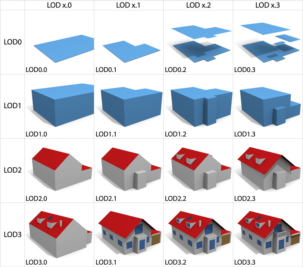
LOD 1 and LOD2 visualizations
Most 3D tools can generate LOD3 visualizations with input from skilled operators. For negotiations however, we want to focus on developing LOD2 visualizations fast and with no input or technical training / support and in real-time. This would provide a way for participants to enrich their conversation and undertake a effective negotiation. At this level the ideas are focused on concepts rather than the details which means that agreements can be achieved fast.
Building Footprint Generation Library
Geodesign is successful when a diverse group of experts and non-experts participate. However, given this, they do not have the skills and time to learn a 3D visualization system and need fast visualization system for their ideas to move forward. The polygons are drawn by participants in a workshop and capture aspirational ideas for the place. When used to generate footprints, the system simple polygons and generates building footprints of different typologies depending on the metadata attached to the polygon. The metadata can be specified in the Geodesignhub administration panel or can be changed / set later as well. Converting a LOD0 polygon to a LOD1 or LOD2 is the core function of the building footprint generation.
What is a building footprint?
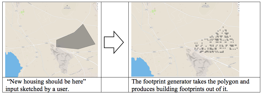
Figure 1 : Concept: On the left is a diagram from Geodesignhub and the footprint generator builds the footprints in real-time.
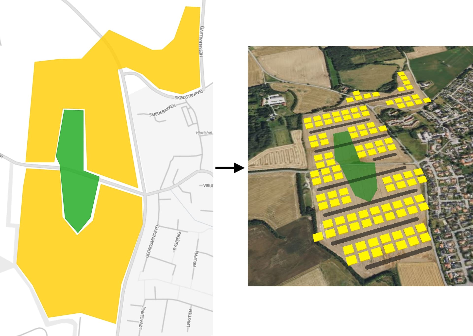
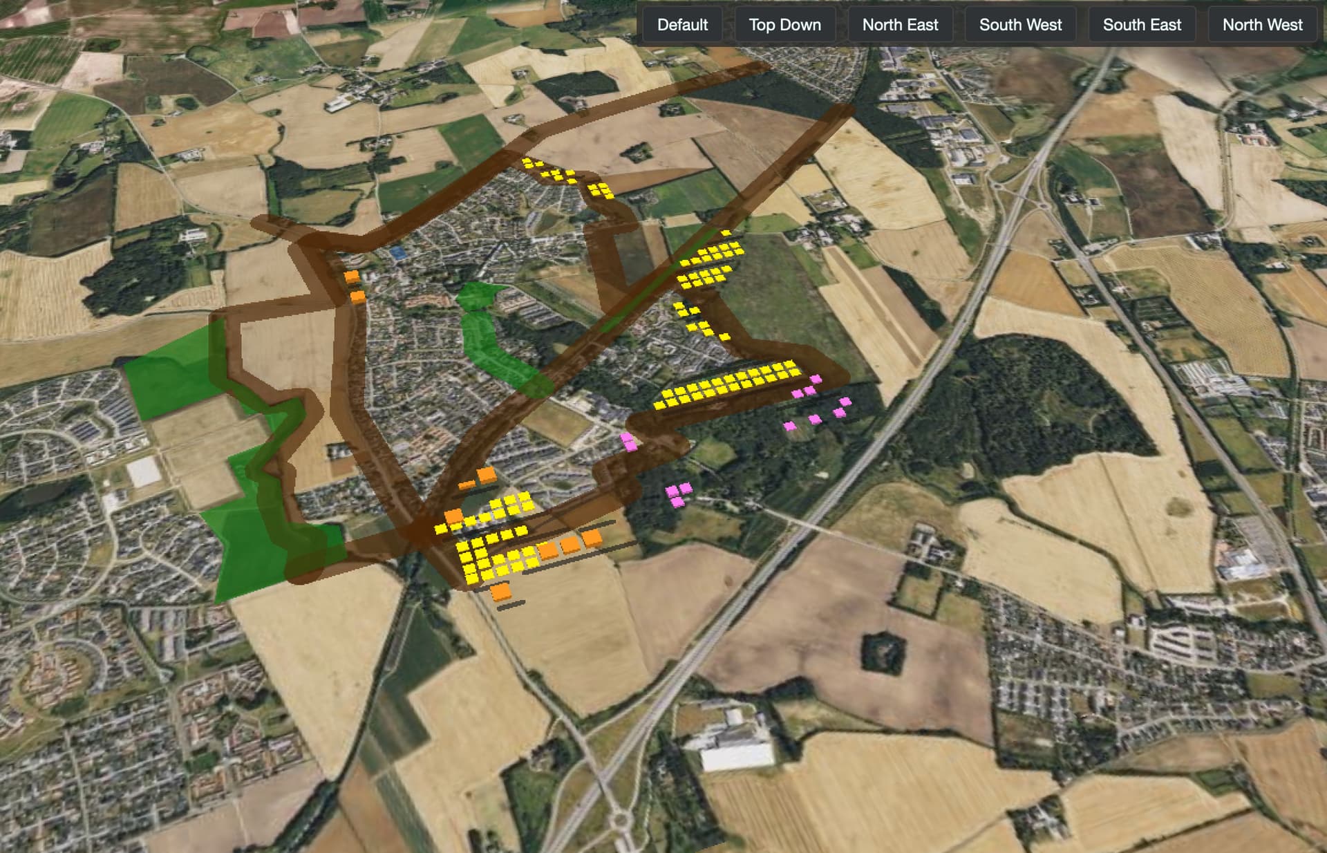
Figure 2: Footprint transformation for a low density housing idea (in yellow in 2D on the left and) and rendered as buildings on the right.
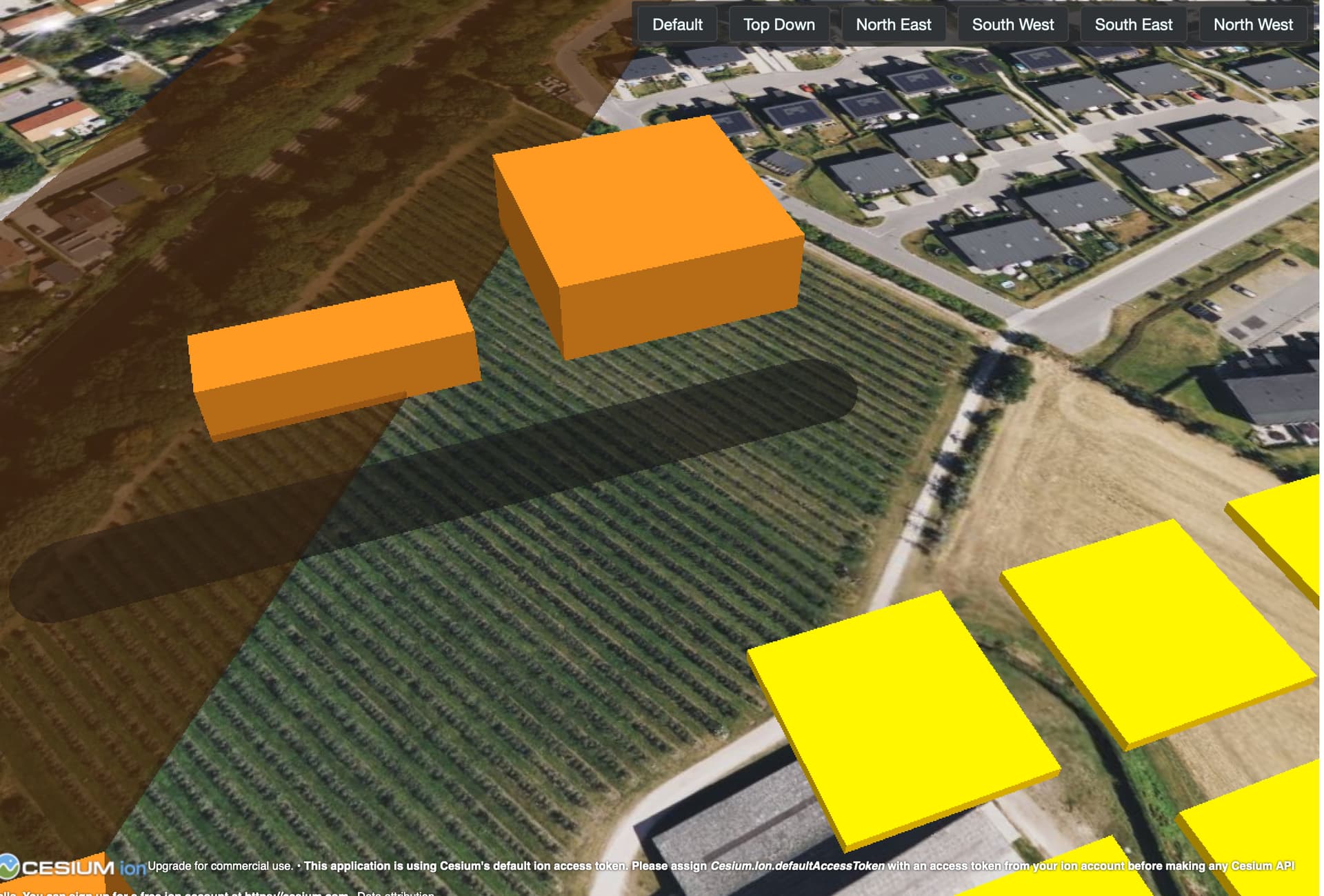
Figure 3: Different types of buildings and layouts.
We have four types of building and street types that can be generated, two of which are shown above. In the future we plan to introduce / add more footprint types can be developed. In addition, since the footprint data can be downloaded you can use it in other commercial 3D software as is the need / use.
Additional Photos
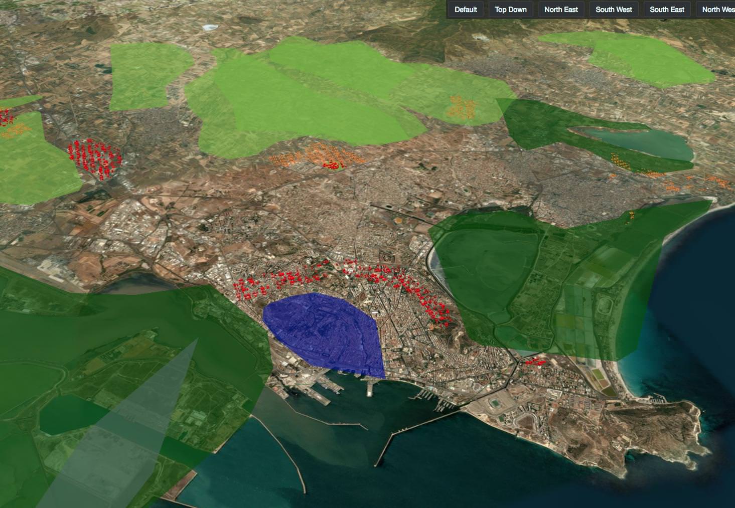
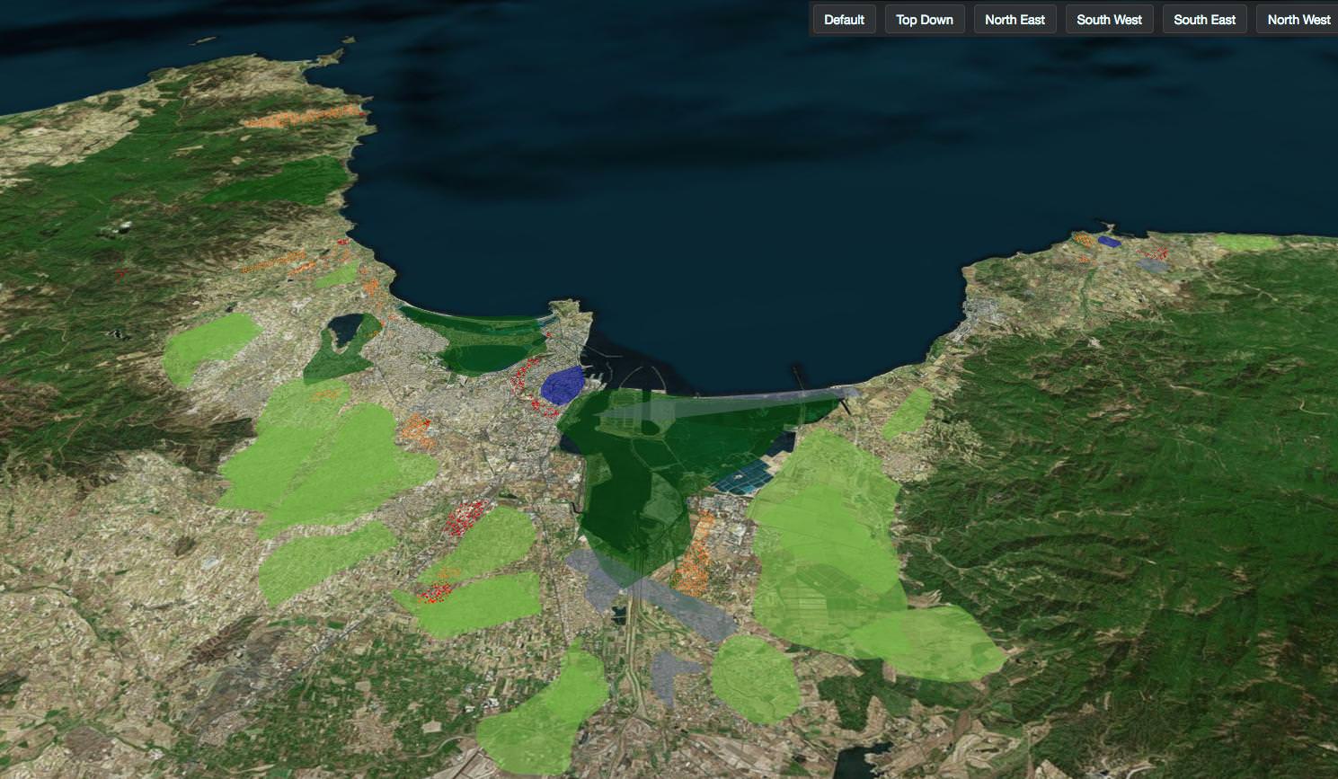
In an 3D environment, of course you can orient the camera in any way that works for your project. You can see other examples where these buildings are seen in the context of the larger area. At early stages of the design, these type of visualizations help in comparison, comprehension and most importantly developing consensus in the context of digital negotiations.
Upcoming improvements
Given the vast applications of this technology, the two priority areas of improvements for the coming months are:
- Addition of traffic / movement of cars
- Addition of tree and grass library
The addition of these two features will enhance the visualization capacity within Geodesignhub and add a element of data richness needed within Geodesign negotiations. Adding these to the negotiations at an appropriate time helps in understanding the impacts at scale in 3D.
When to use it?
This plugin is provided for free for your project on Geodesignhub you can add it using the Administration interface.
Contribute
Globe3D Viewer is included with your project and is provided as an open source project or as a standalone tool. These tools are built and maintained by a small group of dedicated teams that have a passion for the craft.
Programmers: I would encourage you to contribute to these projects, you will really get to know about the intricacies of 3D rather than just learning how to click buttons or write scripts and up your 3D game.
Others: Of course, contributions need not only be in code, you can engage in a number of ways, writing documentation, reaching out to authors, providing feedback and supporting these projects. This is the only way to maintain a healthy ecosystem and contribute.
About Geodesignhub plugins
Geodesignhub provides a very extensive API where everything in the software can be taken out for use with other tools. All plugins including the one above use this API to export data out of Geodesignhub. This enables us to provide “one-click” integration with Geodesignhub, so you can focus on the problem at hand rather than software. If you have the skills and resources to use commercial 3D software of course you are welcome to use them, all the data is available for you!
Footnote
For a detailed background about 3D in Geodesignhub, please review this powerpoint, I will write about the other 3D viewer at another time.