In the context of collaborative decision making, the power of local knowledge cannot be overstated. Today, we’re excited to introduce a game-changing addition to Geodesignhub: our new survey feature. This tool, many years in the making, bridges the gap between community insights and effective map-based negotiations, ensuring that every voice is heard and every perspective considered.
Our survey feature allows project organizers to capture vital local knowledge, transforming it into actionable diagrams that fuel more inclusive and informed negotiations. Whether you’re planning urban developments, managing environmental projects, or designing infrastructure, this tool will help how you gather and utilize stakeholder input.
In this post, we’ll explore how this new feature works, why it’s crucial for successful negotiations, and how it can elevate your Geodesignhub projects to new heights of collaboration and effectiveness. Let’s dive in and discover how we’re making participatory design more accessible and impactful than ever before.
The Power of Inclusive Negotiations
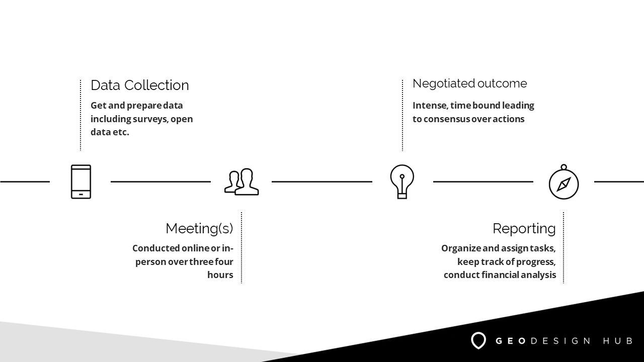
If you are unfamiliar, Geodesignhub enables in-person or online negotiations between different parties. These negotiations are structured and use the Geodesignhub platform to conduct and run them. These are map-based negotiations that have been applied at different contexts e.g. tourism, infrastructure investment, environmental protection etc.
Understanding Geodesignhub Diagrams: The Currency of Collaboration
The way map based negotiations are conducted in Geodesignhub are with diagrams. Diagrams are the currency for negotiations. To conduct high-performant negotiations you must have a good repository of diagrams that cover every aspect the topic that is being negotiated by the parties. This repository must be comprehensive and as complete as possible to avoid any surprises during the meeting. For example when negotiating over how bike tracks should be built, it is very important to have all the existing tracks (to see what we already have), proposed tracks, tracks that are not working well, tracks that need repairs etc. Some of the data may already be present as GIS layers and some may not be. In addition it would be great to have a data about existing parks, existing bus stops. Some of the data may already exist as GIS files, some of it may need to be digitized since it can be in non-spatial format e.g. a PDF etc. In many cases, this knowledge might be in one of the participants minds and it is important to get it as a diagram.
A good negotiation happens when all the possible ideas and concepts need to be negotiated are part of the project and shared with everyone. Trust in a negotiation is built when there is a common set of ideas (no matter how unacceptable) are up for discussion. This brings transparency and helps build trust in the decision making.
Bridging the Data Gap: Why Surveys Matter
The knowledge and experience of the participant is cornerstone of effective negotiation, yet it’s often the hardest to capture through traditional GIS data. While we might have detailed maps of infrastructure or land use, the nuanced understanding of a neighborhood’s character, historical significance, or future potential often resides in the minds of people how have experience in living and working in the place. This knowledge is crucial for effective negotiations. Our survey tool bridges this crucial data gap, complementing GIS data with rich, contextual insights that only experienced people can provide.
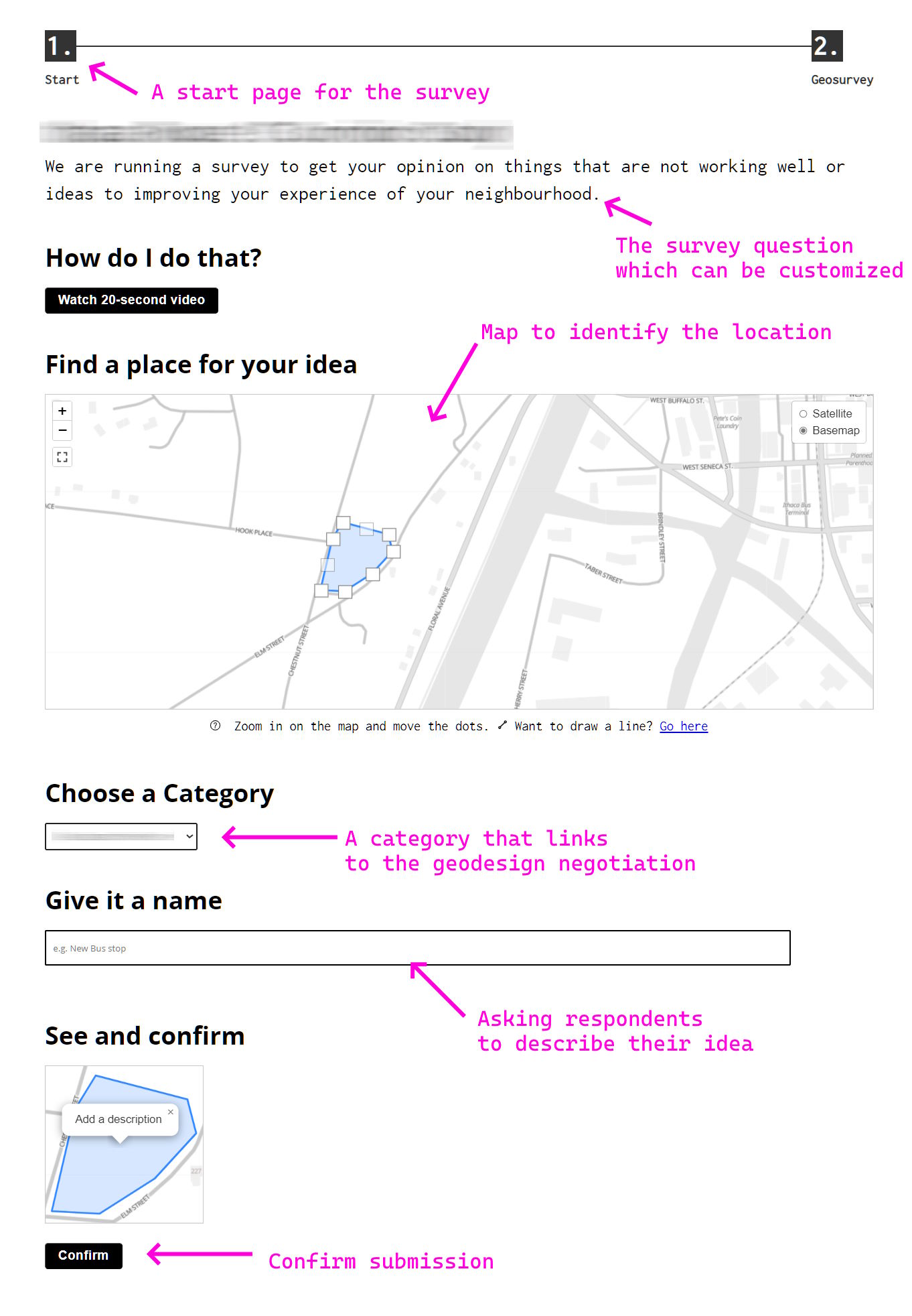
For instance, in a tourism project, GIS data might show all temple locations, but it can’t tell you which ones hold the most cultural significance or tourism potential. This is where our surveys shine, tapping into the collective wisdom of the community to create a more comprehensive and nuanced picture for negotiation. A sample survey page is shown below:
Introducing Our New Survey Feature: Key Capabilities
Our new survey feature offers several key capabilities:
- Anonymous participation, encouraging honest feedback
- No login required, reducing barriers to entry
- Multi-device compatibility for maximum accessibility
- Ability to provide multiple responses per participant
- Comment and upvote functionality for community interaction
- Easy integration with Geodesignhub for seamless workflow
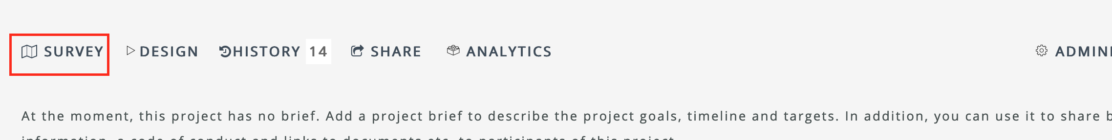
You can see the survey tool in your project as shown below.
How It Works: From Survey Response to Actionable Diagram
Once the survey activity is completed, we’ve streamlined the process of turning valuable input into actionable data for your negotiations. The best responses from the survey are first triaged and migrated into Geodesignhub, maintaining their integrity and context. This process ensures that the local knowledge captured in the surveys is accurately represented in your negotiation as diagrams, creating a direct link between participant input and decision-making.
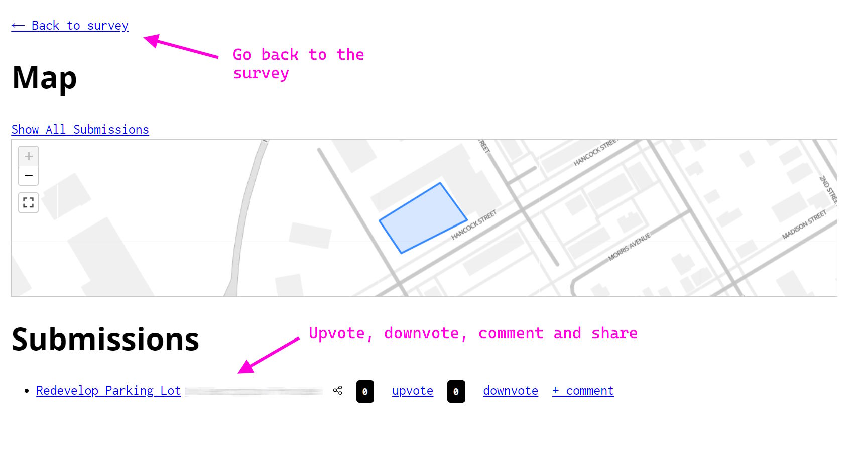
Responding to surveys
In many projects we use these simple surveys to capture local knowledge about the place from participants. These surveys are anonymous, do not need any logins and can be answered via any device. We have used these survey very effectively to engage with many participants and especially people who may not be able to join in person for the negotiations.
At any time all the responses and other data from the surveys can be exported for use in other systems e.g. GIS, and other Business Intelligence tools like PowerBI etc.
Enhancing Participation: Accessibility and Anonymity
Our survey tool is designed with accessibility and inclusivity in mind. Its user-friendly interface and anonymous nature encourage participation from all community members, regardless of their technical expertise or comfort with public speaking.
To maintain the quality and appropriateness of responses, we’ve implemented a robust moderation system. This allows project managers to monitor submissions and remove any inappropriate content, ensuring a respectful and productive environment for all participants.
In many cases these surveys are used to engage people e.g. elderly who are not engaged routinely. We work with e.g. young people and ask them to fill the survey out with their grand parents or parents and it can be used a interesting expertise to engage with the space between different generations.
Beyond Data Collection: Building Trust and Transparency
The survey feature does more than just collect data – it builds trust and transparency in the negotiation process. By seeing their ideas reflected in the negotiations, participants feel heard and valued. This approach creates a sense of ownership and investment in the project outcomes, fostering a more collaborative and positive negotiation environment.
Moreover, the survey serves as a gentle introduction to the Geodesignhub negotiation technology, preparing participants for what to expect during the negotiation phase and increasing their comfort with the process.
When to use the surveys
Surveys are a effective engagement tool with broad number of people who might be interested in the project but may not have the time or might have other commitments to attend the negotiations. Surveys don’t require login or account creation and can be used a way to introduce the technology to the different stakeholders. The survey tool is used in public meetings, online meetings, sometimes people put the surveys on big screens at public places to get maximum interaction and raise awareness of the geodesign project.
Getting Started: Implementing Surveys in Your Project
Ready to harness the power of community knowledge in your next project? Here’s how to get started with our survey feature:
- Set up your Geodesignhub project
- Access the survey tool from your project dashboard
- Customize your project brief and survey questions to fit your project needs
- Share the survey link with your stakeholders through various channels OR hold in-person or online meetings to introduce the survey
- Monitor responses and engage with participants
- Migrate the most valuable responses as diagrams into your Geodesignhub project
- Use the enriched data to drive more inclusive and informed negotiations
Our team is here to support you every step of the way. Don’t hesitate to reach out for guidance or best practices in implementing surveys in your specific context.
Compatibility with other survey tools
There are a few other tools that are available to collect this type form based information e.g. ESRI Survey123, Maptionnaire others. Your Geodesignhub project is compatible with these tools. You can easily import data from these tools as diagrams and you can also use these tools instead of the survey. Geodesignhub’s survey tool focuses on simplicity and enabling a seamless flow in the Geodesignhub method of organizing and conducting negotiations.
Well begun is half done
By introducing our new survey feature, Geodesignhub is laying the groundwork for the way we introduce and setup map-based negotiations. This tool doesn’t just collect data – it captures the essence of embedded expertise and transforms it into actionable insights.
This feature ensures every stakeholder, from seasoned experts to passionate residents, has a voice in a negotiation. It’s not just about collecting data; it’s about weaving local wisdom into the fabric of your project.
Ready to tap into your community’s collective intelligence and elevate your negotiations? With Geodesignhub’s survey feature, you’re not just negotiating for the future—you’re co-creating it.
Talk to us during our office hours today to learn more about implementing our survey feature in your next Geodesignhub project and take the first step towards more inclusive, informed, and impactful negotiations and de-risked decision making.