Introduction
How do you engage people in urban planning? Everyone talks about the importance of Smart Cities and an engaged citizenry but very few experiments have been conducted in regards to citizen engagement and co-creation with professional planners. In some ways, effective public engagement is one of the key links that is missing between the need for planners to connect with citizens. In our increasingly connected society, the inhabitants of a city or town demand that their opinion is not only considered but applied into design-focused results. Geodesign aims to achieve this difficult balance and provide the missing links. Modern geodesign tools enable sophisticated design focused collaboration and negotiation between stakeholders. The geodesign methods open up exciting options for research, experimentation, and practices for different geographies.
As part of a master’s thesis, Karolina Peret and Dr. Hrishikesh Ballal organized a collaborative geodesign workshop involving the inhabitants of Wroclaw, Poland. A first of its kind in the country, this workshop aimed to directly involve Wroclawians in problem mitigation, planning, and even the development of a future city design for Wroclaw, for the year 2030. The city of Wroclaw was concurrently seeking public participation for the “Wroclaw Strategia 2030,” a similar initiative regarding public input for the Wroclaw strategic planning for 2030.
Background
The city of Wroclaw, Poland was the first to host a geodesign event of this kind. The city was chosen for several reasons, including two past floods that inflicted damage in the billions of US dollars, as well as Wroclaw’s historical significance during WWI and WWII. The municipality of Wroclaw has also initiated a strategy in the last few years meant to engage the public so that they may voice their concerns. Unfortunately, this strategy has not had an entirely positive response or effective results.
Prior to the great flood of 1997, Wroclaw had little to no flood protection or flood mitigation strategies. Even after the disaster, the largest flood event in history, and the flood of 2010, the city of Wroclaw has no flood control or prevention measures despite the billions in damage, the hundreds of thousands of displaced people, and the near 60 deaths that resulted from the flooding.
The flood in 1997 was an unexpected and unusual event. The Odra and Vistula drainage basins were both affected by the mid June flood event; with the former resulting in 54 fatalities, 665,000 ha of land flooded, 162,000 evacuees, and billions in US$ of damage. Before the event, commonly known as “The Great Flood of 1997”, only minor floods occurred historically. During the early and late 1980s, Poland was stimulating growth and focused on catching up with the rest of Europe, following the fall of the former socialist political system. In an effort to stimulate development, money was heavily rerouted to education, economic development, social programs, health, hospitals, and funds formerly allocated to flood prevention was low and continually decreasing since vulnerability to a major flood event was not anticipated (Kundzewicz et al, 1998).
Odra Hydrology Background
Long term mean annual flow at mount of the Odra is 575 m3s-1. Typically, there are 2 high flow periods; spring snow melt, and intensive summer precipitation. The national annual precipitation of an area 312,000 km2 is roughly 618 mm, approximately 193 km3 of water as estimated, based on 1951-1985 statistics. Approximately 55 km3 of water runs off land areas yearly. Annual precipitation for the Dolno-sląsk region is 592 mm, below the national average. Statistically, this is one of the lowers in the European Union and Poland contends with a water deficit, a common problem for the nation. Low flow situations are frequent and on average, the basin is water-poor.
However, numerous floods along the Odra since 1997 have necessitated flood protection systems, such as embankments, weirs, reservoirs, and relief channels. The heavy precipitation filled much of the natural water retention saturating available water soil storage (Kundzewicz et al, 1998). Researchers have recently suggested that climatic changes and shifting weather patterns will alter the frequency of 100 or 1000 year flood events, particularly in central Europe, making them more frequent (Szalinska et al, 2014).
The Problem
The issues the geodesign workshop aimed to acknowledge and solve were predominantly environmental ones, addressing the historical floods, poor air quality (particularly in the winter months when coal burning facilities are at peak operation), and traffic congestion that concentrates outside of the “stare miasto” or old town center. These problems, along with a lack of open space and water maintenance, increasing populations, degrading street networks, poor electrical infrastructure, poor garbage maintenance, and a desire for Wroclawians to nurture their connection to the “rynek” or market square, were the main drivers steering the geodesign workshop and its participants.
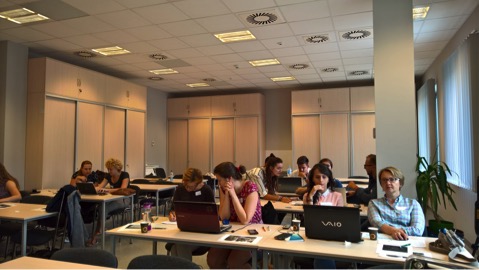
Geodesign Workshop
A mixture of 15 individuals from the public with various backgrounds in programming, planning, geodesign, architecture, and finance all attended and worked together to create democratic and comprehensive plans for the future of Wroclaw, 2030. The workshop involved a one day interactive, design planning negotiation. Organized through emails, social media, flyers around the city, and word of mouth, the event was organized by the University of Life and Environmental Sciences Wroclaw and the Polytechnic University Wroclaw. A radio interview with RadioLUZ, a public university radio station at the Polytechnic University, discussed the problems encompassing Wroclaw with Karoline Peret. The issues discussed included the flooding issues, growth impacts, progressive ideas in planning, and how to get involved in the workshop.
Geosurvey results showed an unequivocal support to add more green spaces, particularly in the regions surrounding the Odra river and the Podwale canal on the south side of the city. Almost every respondent expressed their thoughts about the essence of city enjoyment, the river, and the spaces for walking, biking, and exercising. The majority of Wroclawians expressed the importance for efficient thoroughfares, public transportion, walkability, and the use of these areas as meeting spaces, restaurants, and cafes that people would want to spend time in. Almost all of the responses referred to the center of the “stare miasto,” or old town at the “heart of the city,” and adamantly supported that the maintenance and uninhibited access to this area was crucial for the future development of the city.
Click link to read geosurvey questions: https://goo.gl/forms/bIbBYwX0G38crrYp1
Many of the respondents also mentioned the Wroclaw “islands” and the ability to escape the bustle of the city center into a space that is, proximity wise, only minutes away from the old town but still gives the impression of an “escape.” The majority of respondents made it a point of stating the importance of clean, healthy watersheds, from the Odra river to the man made canals on the south side of the city (Podwale) to the wetlands, as well as the tributaries which connect and flow into the main Odra channel.
Outcomes
This workshop was crucial for Wroclaw, and Poland as well, since it demonstrated that a democratic planning process is not only possible but relatively simple to engage with public and execute. Even those from backgrounds unrelated to planning or architecture were able to visualize the designs and think strategically. Since the current approach to planning is not involving the public as much as it should, or is doing it ineffectively, the need for this type of process is becoming increasingly important. The feedback received from participants was positive, as many people believe that a geodesign approach of this nature is the future of planning. Outcomes of the workshop resulted in several cohesive and well thought out concepts, which could be applied to future scenarios in Wroclaw.
We asked the participants for brief, concise feedback post workshop, and this is what one participant had to say about his involvement:
“I’m a foreigner and living in Wroclaw for one year; I found [the workshop] exciting because I met with people who have lived here for many years, and I was able to work with people who can change something in the city. And by this I mean, being able to put on the paper their thoughts, this is what I really like. I wish I could apply this concept and participate in a workshop in my own city [Russia].” -Sergei
Biographies
Karolina Peret is currently completing a Masters of Science in Sustainable Urban Planning and Civil Engineering at TUHH in Hamburg, Germany as part of the JEMES CiSu program. Originally from outside of Wrocław but Canadian born, this co-hosted event workshop is part of her thesis project. Karolina has a BSc in soil remediation and a BASc in biogeochemistry.
Dr. Hrishikesh Ballal is the managing director of Geodesign Hub, he has a PhD in geodesign at University College London’s Centre for Advanced Spatial Analysis and is interested in collaborative design.
Acknowledgements
Dr. Hrishikesh Ballal for mentoring me, flying to Wroclaw and organizing/conducting the workshop. Dr. Pettit, Dr. Fröhle, Emil Lanfranchi, Fransesco Fonzino, Anna and Olivia Sozanski, Dawid Brzeźny, Jan Kazak, Martyna Wilk, Bogna Kietlinska and any one else I may have forgotten who helped support me in some way.
Dedicated to: Dziadek Feliks Tomalik for leading the underground ‘AK Armia Krajowa’ in Kępno despite the life threatening risks, for your bravery in Auschwitz, and for the rebellious heart which I clearly inherited after you. RIP FT #171236.
References
ZBIGNIEW W. KUNDZEWICZ , KRZYSZTOF SZAMALEK & PIOTR KOWALCZAK, 1998, The Great Flood of 1997 in Poland
Precipitation extremes during flooding in the Odra River Basin in May-June 2010 Wiwiana Szalińska, Irena Otop, Tamara Tokarczyk, 2014
 See you in Brazil!