1- INTRODUCTION AND THE CASE STUDY
The Quadrilátero Ferrífero was chosen as a study area due to its importance in the context of the State of Minas Gerais. This region brings together great variety and richness of natural elements, in this is inserted, for the most part, the economy of the State of Minas Gerais, having the mining as an economic symbol.
The region is located in the center-southeast portion of the state and occupies an area of approximately 7,000 km². The taxonomic origin of the region was named by Gonzaga de Campos (RUCHKYS, 2007, apud DORR, 1969; SCLIAR, 1992), due to the iron ore deposits found there, located at extreme locations in the municipalities of Itabira, Mariana, Congonhas and Itaúna, which are geographically arranged quadrangular in the territory in question.
The region has many mineral resources, being one of the two main mining provinces of the country. In addition, there is a wide range of other relevant factors such as local landscape, type of vegetation occurring only in this area, source of important rivers in the formation of the regional and national water network (SILVA, 2007). It is also observed a significant amount of patrimonial assets, due to their occupation by the colonizers in the phase of historical importance of formation of the Brazilian society.
The region has the most diverse conflicts of interests, which justifies its choice for investigations regarding the use of Geodesign methodology
In this context, a thematic Geodesign Workshop was conducted, linked to geology as a planning base for the area in question. What Geodesign generally consists of methodological steps that seek to make more effective and symbiotic the collaboration between some design professions, geographic sciences, information technology and people who will be impacted by changes (“people of the place” ). It is considered that all these groups aim at changes to improve the environmental and social conditions present in the study area. (STEINITZ, 2012).
Thus, in the present work, seven main systems were used to evaluate the proposed theme, which are: Vulnerability to urban use in a Geological and Geomorphologic context; Hydrological Vulnerability Associated with Porosity; Speleological Vulnerability; Vulnerability of Vegetal Cover and Conservation Unit; Mining Attractiveness; Tourist Attraction in function of Geology; New.
The variables considered, for each system, were processed using spatial analysis techniques, and later related to each other through the multi-criteria analysis, resulting in the final evaluation map for each system.
2- METHODOLOGICAL PROCEDURES
The methodology presented was the elaboration of thematic systems, linked to geology (Figure 1), for the workshop. Initially, the variables for each system were elaborated, then the variables analyzed in the GIS software, the calculation was performed by weighted average of the variables, which made possible its integration with other variables related to the territorial and environmental planning strategies of the study area (MOURA , 2005).
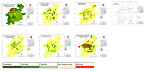
Figure 1: Evaluation Model of each system used in the Geodesign Workshop. Source: The Authors
3- RESULTS and CONCLUSIONS
From the results of the evaluation maps, the first iteration was the workshop held on September 15, 2017, with the presence of professionals related to mining (geologists, geographers, engineers and biologists).
It can be observed that since the first scenario, due to a similar professional performance of the participants, the project of each group was already very similar, to the point that the initial scenario to the final scenario there were few changes. Basically what happened was the formatting and adequacy of the ideas initially proposed.
ACKNOWLEDGMENT
Dr. Hrishikesh Ballal and Dra. Ana Clara Moura for helping this to happen.
REFERENCES
DORR, J. V. N. 1969. Physiographic, stratigraphic and strictural development of Quadrilátero Ferrífero, Minas Gerais, Brazil. USGS/DNPM. Professional Paper 641-A, 110p.
MOURA, Ana Clara M. Geoprocessamento na Gestão e Planejamento Urbano/Ana Clara Mourão Moura. 2. ed. Belo Horizonte: Ed. Da autora, 2005. 294p.
RUCHKYS, U. A. Patrimônio Geológico e Geoconservação no Quadrilátero Ferrífero, Minas Gerais: Potencial para a Criação de um Geoparque da UNESCO. Tese de Doutorado. Universidade Federal de Minas Gerais, Belo Horizonte, Minas Gerais, Brasil, 2007, 211 p.
SCLIAR, 1992, Geologia da Serra da Piedade. in: Horta, R. D. (org) Serra da Piedade. CEMIG, Belo Horizonte, 136p.
SILVA, F. R. A Paisagem do Quadrilátero Ferrífero, MG: Potencial Para o Uso Turístico da sua Geologia e Geomorfologia. Dissertação de Mestrado. Universidade Federal de Minas Gerais, Belo Horizonte, Minas Gerais, Brasil, 2007.
STEINITZ C. A Framework for Geodesign: Changing Geography by Design. 1. ed. Redlands, CA: ESRI Press,2012. 360p.