Team: Raghda El-Nezory, Rasha Abd El-Rasoul, Doaa Ali, and Asmaa El-kafrawy- Ministry of Tourism and Antiquities, Egypt.
Supervisor: Dr. Mohamed Soliman- (DMUCH) Ritsumeikan University, Japan
- NRIAG, Egypt
1. Introduction
Each community has its own definitions, desires, dreams, and paths toward development. Accordingly, the role of the planner is to expand opportunities for each citizen. So, the national sustainable development strategy (NSDS) Egypt vision 2030 represents a foothold on the way towards inclusive development and focuses on three main pillars, economic, social, and environmental.
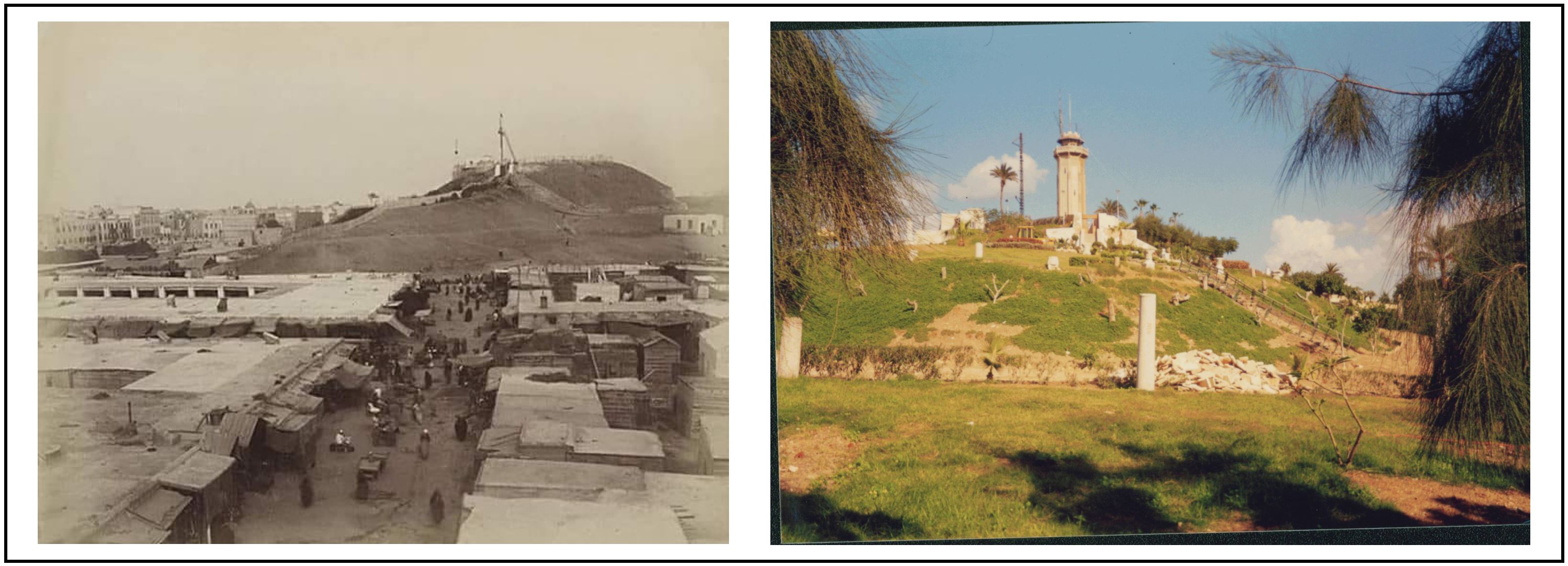
Recently, in support of the Japanese Society for the Promotion of Sciences (JSPS); the Institute of Disaster Mitigation of Urban Cultural Heritage (DMUCH) Ritsumeikan University in collaboration Geodesign-Hub develop a project causes of the sustainable Geodesign for the urban cultural heritage of Alexandria, Egypt 2030 that encourages archaeologists to focus on the contemporary city and the high potentiality of its heritage. In the light of contemporary urban transformation, Geoedsign should be enabled to deal with the heritage of Alexandria in spatial planning and design projects. Our project focus on one of the outstanding archaeological sites of Alexandria, “Kom al-Nadura” which is one of the most important two hills that distinguished the city. Kom al-Nadura is a cumulative hill that covers 6.5 acres and raises up to 25m above sea level Kom al-Nadura was known as “Kom Wa’la”, in reference to Abd al-Rahman ibn Wa’la al-Sabi al-Masri, the famous companion of ibn Abbas, the famous companion. Al-Salafi and Abu Bakr al-Tartoushi in c. 12th CE. / 6th AH. In the Fatimid period, a new tower was built at the top to observe and monitor the ships in the western port, which is remained the subject of the attention of Caliphs and Sultans until it was rebuilt again in 1926 CE of 25m height. During the French campaign 1798 - 1801 CE, Napoleon Bonaparte ordered the construction of a fort known as " Tabiya Caffarelli", attributed to " De Valga Caffarelli," one of the military engineers of the French army, who died during the siege of Acre in April 1799 CE. During the reign of Mohamed Ali Pasha and his successors, a cistern was established in 1839 CE, a small observatory to study astronomical sciences and the beginning and end of the months. However, Kom al-Nadura includes a variety of archaeological features including barracks, tombstones, and a park filled with large numbers of coastal cannons.
2. Objective and Approach
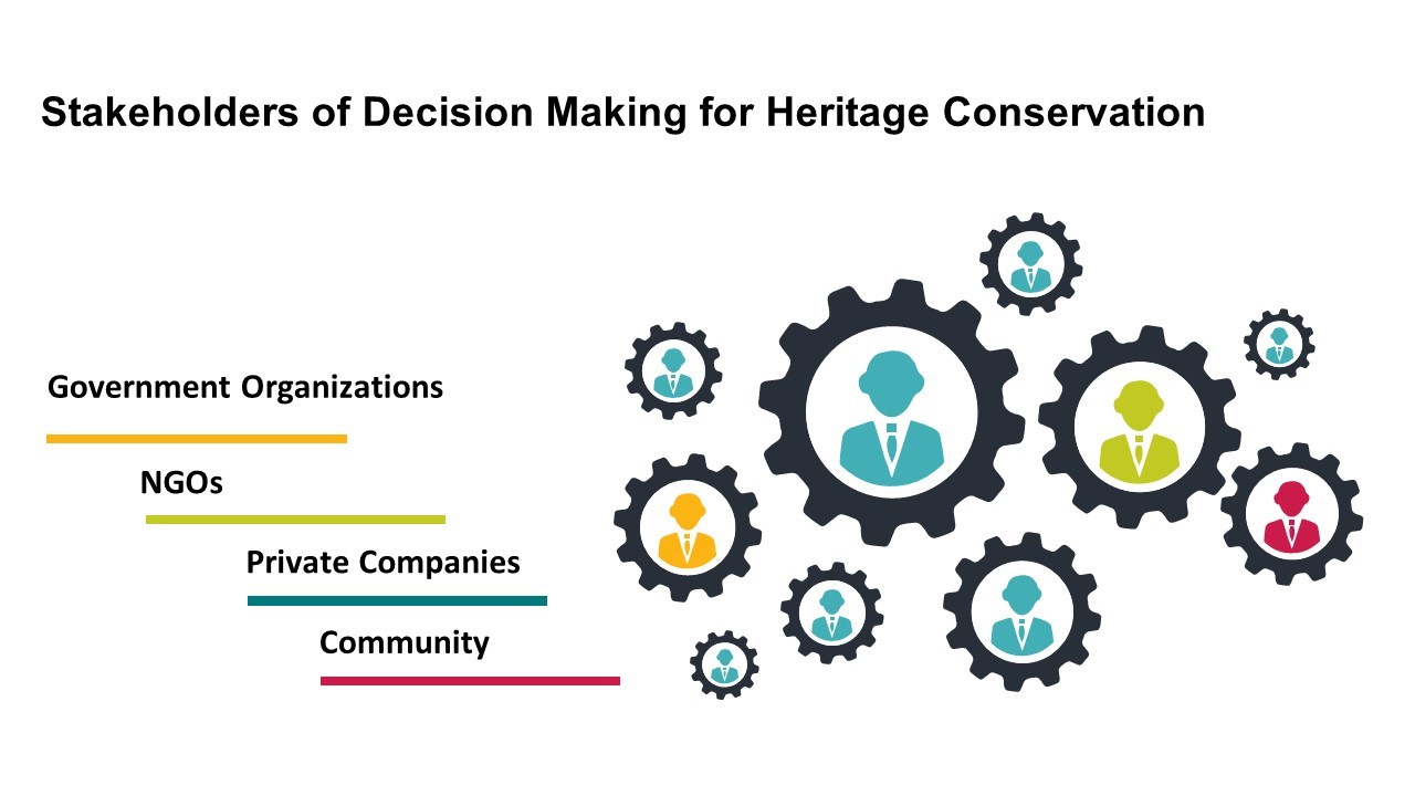
Egypt NSDS 2030 vision needs to be linked to a very flexible project based on an approach to keep up with changing social urban and economic situation for populations, who need to see their environment improving rapidly, particularly NSDS 2030 has followed the sustainable development principle as a general framework for improving the quality of life and welfare. So, the project aims to create a new designs in the areas of heritage value in order to achieve visual continuity for its historical urban context. In this regard, the project vision is achieving sustainability through integration among the relevant stakeholders, basically official institutions, the private sector, the local community, and NGOs. Accordingly, our methodology is how spatial intervention based on the Geodesign framework can be connected with heritage information especially in “Kom al-Nadura”, on the other hand engaging it to the urban area via providing more flexible accessibility will enhance development opportunity (Fig. 2).
The project faces two main challenges; first, is achieving protection and development criteria of heritage, second is adopting an implementable change model of land uses, particularly transportation. However, the project considers the strategic plan targets for preserving Alexandria’s cultural heritage that includes Kom al-Nadura. On the other hand, the transportation system aims to improve the urban mobility for visitors and tourists to Kom al-Nadura, taking into account the environmental consideration and the socio-economic sustainability of the local community. Environmentally, the existing transportation system around Kom al-Nadura represented in noise and pollution impacts negatively on the site, as a result, the project adopts a design for harmonizes the urban mobility around Kom al-Nadura. In the same context, the high-density urbanism of Alexandria pushes to create a design that improves the public space surrounding Kom al-Nadura, in line with the vision of Egypt 2030, Alexandria in particular.
Fig (2). Stakeholders of the project
3. Transportation:
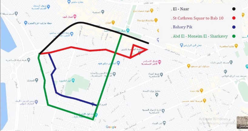
Our team adopts transportation development as the road network suffers from traffic congestion, as a result of the high-density urbanism and topographical characteristics of the city. Transportation design model upgrades Kom al-Nadura from Sant Catherine to Bab 10 Tram stations. Developing a bus station in Bab 10 area is the ultimate requirement, especially Bab 10 is the main gate of Alexandria harbor. Developing Sant Catherine Tram Station comes as a part of upgrading the infrastructure and substructure of the Alexandria Tram network, as well. Second target is creating smart traffic lights on streets, such a system is perfect to systemize and control the urban mobility flow crossroads surrounding Kom al-Nadura, aiming to achieve smooth traffic. Accordingly, identifying two streets smart traffic lights for pedestrians; one extends between Bab 10 and Sant Catherine (al-Shaykh Mohamed Shalaby St.), while the second extends from Mahmoud Moustafa St. to the south of Kom al-Nadura. In the same context, Bab 10 and Saint Catherine axis via al-Mansheya square, will be adopted as a pedestrian street suitable for walking around the historical urban fabric. Additionally, establishing a smart taxi stop for the first time in Egypt. It is dedicated to the eastern side of Kom al-Nadura, in order to enable visitors to reach the area easily. Eventually, creating a circular one-way road to improve the flow of traffic and vehicle speeds up and its intersections are simpler, thus adopting four streets as one-way street surrounding Kom al-Nadura core zone; east: al-Saba’ Banat St., west: al-Seka al-Gadida St., south: Bahary Bek St., finally Warsha al-Topgaya in the north (Fig. 3).
Fig (3). Transportation change model of Kom al-Nadura
4. Heritage (management):
One of our targets is how to develop the site, this process involves various development parts concluded in 6 targets:
Firstly, a windbreak will be made a hedgerow around the edge of the site, which is a planting usually made up of one or two trees planted to mitigate land sliding, reduce the cost of heating and cooling, keeping the hill and the landscape away from the rain drifting, furthermore preserving the panorama of the site from the main roads. This will improve the site landscape by reducing the visual incursion of the roadway and mitigating the noise of traffic jams.
Second one is an open museum, which is a community museum that will be found in the hill park will be considered the outreach arm for the public because we will display exhibits dating back to different eras. These exhibits including large numbers of coastal cannons, columns, tombstones, and pottery pots.
Third one is developing bazars, which will be a big Souq in which traditional handicrafts distinguish Alexandria and souvenirs will be displayed supported with other facilities such as, junk food shops and public utility.
Fourth target is a visitor center that will introduce a room equipped with digital screens to display the history of the site.
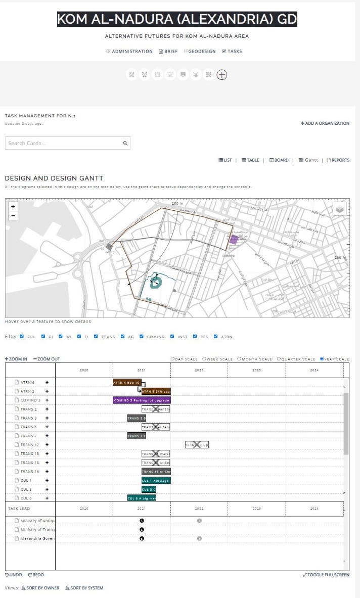
Fifth target aims to develop the maritime signal tower as a tourist observatory, due to its advantage of 24.5m height. The last project is adapting the barracks to be used as a restoration pottery lab and pottery workshop, in addition to the archaeological documentation section (Fig. 4).
Fig (4). Alternative future of Kom al-Nadura
5. Conclusion and results:
The concept of Kom al-Nadura project argues for the positive integration of cultural heritage into urban development and policies as a way to upgrade the sustainability of Alexandria cultural heritage, in the light of (NSDS) Egypt vision 2030 for achieving the sustainable development goals. They had chosen some important projects which support the improvement of the government’s plan in developing our country. On the other hand, Kom al-Nadura project provides a good opportunity for young archaeologists of the ministry of Antiquities to learn a new technique, especially those who work at heritage preservation in different fields. However, firstly we use Geodesign hub to achieve an improvement in the transportation of Kom al-Nadura site, which aims to organize roads to reduce the traffic pressure and increasing the capacity, and improving the quality of public transportation in the area. Second, choosing a supplementary project to accomplish the development targets in Kom al-Nadura, which represented in adaptive reusing of some monumental buildings. Targets are concluded in a Bazar to let tourists remember this unique site and others to facilitate services to visitors. The northern side of Kom al-Nadura will be supplied with a staircase and path.