In this article, I am going to introduce a exciting new feature that is now available for your projects: computing travel times using the existing street network.
Reachability Analysis and Isochrones
My knowledge of this topic is limited but, a Isochrone map is a fairly standard way to compute and visualize travel times. To simplify it a bit a isochrone map takes in a transport network and computes travel times from any point, you can see for yourself using this really great Mapbox-built visualization or the Wikipedia page above. This type of analysis can be used to many things including for e.g.
- How many people will visit this location?
- What is the expected foot traffic to / from a metro / bus station?
- Building strategies for densification.
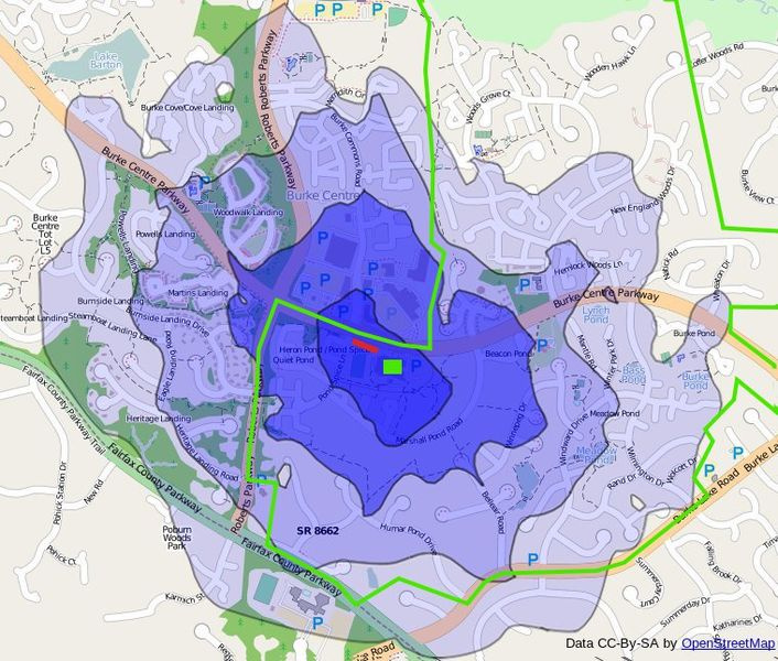
A sample isochrone map is below (from OSM)
Isochrones using Openstreetmap
Openstreetmap maintains a constantly updated database of the transport network. It is actually amazing the amount of transport data that is available on OSM. Routing using Openstreetmap is as old as OSM itself (e.g. see OSRM). I recently came across another very interesting project: Openrouteservice and Graphhopper. I knew about Graphhopper the company and found out about Openrouteservice via Github. Both projects are using the open source Graphhopper code base.
From a geodesign point of view, I was very curious about the Isochrone API that this project provides. All of isochrone computation is done using OSM street network.
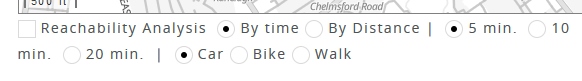
At Geodesignhub we use the OSM database as our “base data” to build map tiles and power other features on the platform, so we have a copy of the OSM “planet” file and I thought it would be great to connect the Openrouteservice code to that file. So after working on it over the past few weeks and setting a server and deploying it, it looks like the following on Geodesignhub ![]() :
:

You can choose to between travel time and distance, as we progress, additional options will be added to compute the isochrones. The control is available below “My selections” section in Geodesignhub and looks like below.
This type of analysis is critical for urban development / management projects and using Openstreetmap and opensource tools we are able to provide state-of-the-art transportation travel time analysis for your design projects.

The computation required for this kind of analysis is significant and so is the hardware capability necessary because this is available worldwide (!). This is already very mature technology but as we develop a deeper understanding of it, I imagine it will be a central part of any design analysis and will be made available for free for all geodesign projects.
Limitations
As I mentioned in the beginning of the article, this features uses the existing transport network as defined in OSM, it does not take into account any new interventions built using Geodesignhub e.g. bike or road projects, so to that extent it is not a cost-distance matrix computation. But I think that using OSM data to provide travel times provides a very solid foundation for analyzing interventions. We plan to use it in January on a BRT route and stops management project (more details soon!).
Do you know more about Isochrones? Share your understanding using the comments below!
![]() Happy new Year!
Happy new Year!
NB: December 2018 Given the complexity of the technology, this feature is currently available only for paid projects and it will be available to all projects over the next few years.