Quote from the master dissertation of Lingxiao Li-‘ Geodesigning green networks with recreated abandoned areas: Case study of Birmingham’ submitted to the Landscape Department at University of Sheffield on September 2017
I would like to express my sincere heartfelt thanks to my supervisor, Olaf Schroth and Hrishikesh Ballal for their contributions to my thesis.
Introduction
Transforming abandoned areas into green space is recognized as a multidisciplinary task from aspects of landscape, soil, hydrology, engineering, ecology, history and social science (Dixon et al., 2008). Most data about the sites in question look at geography through the application GIS software to evaluate the suitability of the site for potential green space, and how it can be part of a wider green network. Furthermore, accounting for social demands, and end users’ satisfaction of the landscape is significant for maintaining long-term remediation. Therefore, collaboration of participants in this design process is necessary (Swaffield, 2013).
To satisfy the above requirements, Geodesign has been used as the framework in my master thesis to study how to combine proposed green spaces regenerated from abandoned areas into citywide green networks. It discusses the process of determining which type of green space is best for which abandoned areas, and how Geodesign can be applied to explain how abandoned areas can become a network of green spaces. Using the city of Birmingham as a case study, the suitability analysis of abandoned areas and stakeholder feedback are two main components of the research.
Preparation for online voting in Geodesign hub
In this research, due to time restriction and control of a single variable in the interaction research, all scenarios are proposed by the researcher instead of a workshop with several teams responsible for different aspects in the practical Geodesign process. It focuses on the study of public replies to the decisions online through Facebook, email and other social networking mediums to attract more public attention and attendance.
With the assistance of suitability analysis based on ArcGIS, text descriptions of proposals are able to be quantified into digital form to regulate the suitable scope. It is beneficial to ensure the accuracy of delivering planning policies and standard from governments and agencies.
After evaluation maps and planning proposals are uploaded into Geodesign Hub (Geodesignhub), the online voting was generated to receive stakeholder’s feedback. The vote was about 5-15 minutes with 32 alternatives. It is convenient for participants to choose the schedule and place to take part in the online vote through their own laptop or mobile phone.
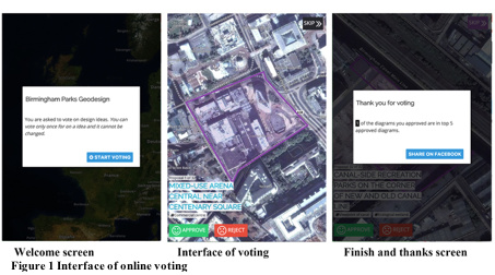
Interface of online voting
It includes three main interfaces, including welcome page, interface of voting, and thanks screen as Figure 1. While participants enter the voting system, the overview map of the country the study site belongs to is presented first, the target area is gradually zoomed in from the scale of the whole nation. For each option, selected diagram is introduced on the satellite map which is available for participants to zoom in and out, and to check the site location and condition of context. These participants are people who ever or nowadays visit, study, work and live within the study area- Birmingham urban and sub-urban area, particularly those whose study fields are related to landscape architecture and urban planning.
Promote the online voting
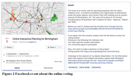
This vote is mainly promoted as an event posted on Facebook as Figure 2. The picture including site location and planning proposals is used as the cover photo of the event to attract more potential participants who are concerned about Birmingham development. Besides, the address of this event is set as New Street Station to enlarge its opportunities to be seen by more local people. Informed with the consent form and participant information sheet of the event first, participants take part in the online voting through clicking the link (this link is expired now). The duration of this voting is 3 days from 5th September to 7th September 2017.
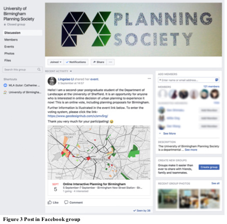
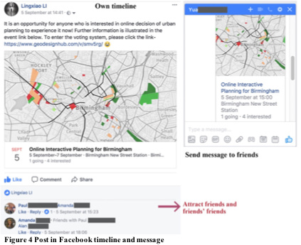
Furthermore, this event is also post in Birmingham local groups on Facebook, which are related to urban planning (Figure 3), and post in my timeline to attract friends and friends’ friends who care about Birmingham urban transformation (Figure 4).
Collection of the results
This three-day online voting totally collected 819 votes, including 692 approvals and 127 rejections. With the assistance of Geodesign Hub’s founder, Hrishikesh Ballal, the data, containing IP address, time, and corresponding decisions for each option, is collected in the form of Excel tables. Due to data confidentiality stated in the application of ethic review, identifying information like IP address is not analysed and illustrated in this research.
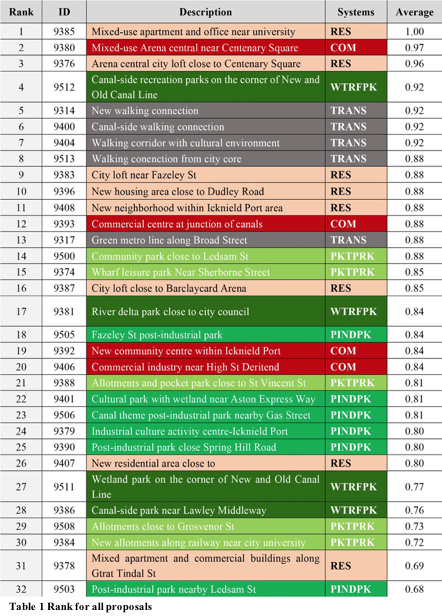
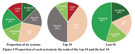
The degree of public agreement towards one proposal is measured by the average of ‘vote’ column, in which digit ‘1’ and ‘0’ respectively correspond ‘Approve’ and ‘Reject’ in the original data. According to this measurement, passing rate of proposals is 84%, and proposals are ranked in Table 1 through ‘Subtotal’ and ‘Sorting’ tool in Excel software. Furthermore, top 10 and last 10 favorite proposals in Table 1 are concluded in the form of pie charts for further analysis of public desirability towards remediation of abandoned areas in Figure 5. To decrease the disturbance original system priorities within this vision, this is also tallied as a reference in this figure.
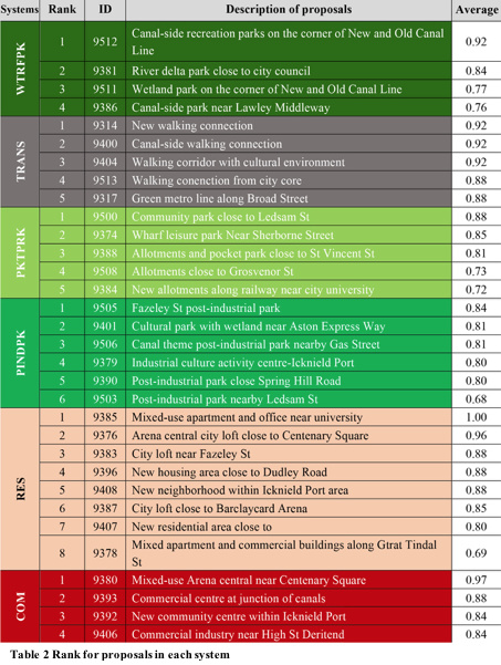
In condition of further study about public feedback towards these systems, rank for proposals in sort of system is listed in Table 2.
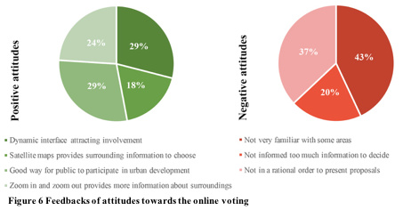
Besides, after finishing the online voting, eight participants gave their feedbacks about qualitative characters of this online voting. The positive and negative attitudes towards this voting are illustrated in Figure 6. Most participants appreciate the dynamic interface of this online voting.
Discussion
With deference to the other part of the results, online voting indicates the advance of social network and quantitative feedbacks. Firstly, promoted in the local Facebook group and friends’ timeline and recommendations, more and more people who are indeed concerned about the project or real stakeholders near to the development areas decides to participate the voting (Figure 3). Within three days, 819 votes are collected and recorded in the background program-running, which is really convenient for researchers to summarize them for further study in contrast to the traditional paper questionnaire. Compared to face-to-face or online workshop, the result of online voting may appear more deviations due to totally-exposed to all people familiar or unfamiliar with the site, professional or non-experts, and unknown situations when they select the options, with deep consideration or random selection (Evans-Cowley and Hollander, 2010). However, this residual can be decreased in rational scope when enough sample size of participants is involved in this quantitative research (Slotterback, 2011). This solution is easy to be reached due to the mass of participants within three days in this research.
Besides, qualitative research is also added into the research to achieve general assessment towards quality of voting systems itself, which is summarized in Figure 6. According to those positive feedbacks, the dynamic interface (Figure 1) is indeed attracting more people to participate, and leads them to finish the voting. It is confirmed that options based on GIS databases allow participants to give more interactive feedback after further understand the site location and existing land cover (Slotterback, 2011). It reflects large potential value for improving public involvement in urban planning and development of politics and advocacy (Evans-Cowley and Hollander, 2010). At the aspect of negative attitudes, most problems come from lack of comprehensive information about each proposal and context. In my opinion, these problems could be solved if other backgrounds, including map of land use, transportation and so on, are provided to participants to refer for decision making.
Significantly, the method and process stated in the research are capable to be directly applied or referred by more projects about regenerating abandoned areas into green spaces or green networks. It simplifies the complex planning process of remediation, containing various factors, into six steps of Geodesign with a series of quantified standards. This research provides a collaborative method to quantify the process of evaluation and decision-making, which is suitable to be applied to planning policies and projects by agencies and the public to achieve targets of sustainable development of environment especially abandoned area.
Although both of this research and the graduation design I submitted in June, 2017 take attitudes and sense of stakeholders into consideration to shape the project, the emphasis of them are dissimilar. At the planning phase, this research takes shorter time to propose all suitable and convincing diagrams in contrast to repeated comparison and overloaded Geo-based sources in traditional planning phase. Furthermore, according to difference of scales between this research and design stage of my graduation design, this research provides a more rational analysis and evaluation of Geo-data rather than the public experience of space and landscape which is not only focused in the design project, but also in traditional landscape architecture. Besides, the project in this research involves public decisions towards proposals, in contrast proposals are proven only through 3D models about space experience in the graduation design, which is not a totally persuasive project.
Last but not least, it possesses a great research value of the subject concerning the application of online participation to urban developments, planning decisions and policies adopted by local governments and agencies. Social networking has more advance to connect neighbours, and is essential to enhance social welfare and local life. This benefit can be enlarged through further study of the relationship and collaboration between the online participation tools and as a complement to traditional methods of participation (Evans-Cowley and Hollander, 2010).
References
Birmingham City Council. (2017). Birmingham development plan 2031. Available from: https://www.birmingham.gov.uk/download/downloads/id/5433/adopted_birmingham_development_plan_2031.pdf [Accessed 12nd January 2017]
Dixon, T., Raco, M., Catney, P. and Lerner, D. N. (Eds.). (2008). Sustainable brownfield regeneration: Liveable places from problem spaces. John Wiley & Sons.
Evans-Cowley, J. and Hollander, J. (2010). The new generation of public participation: Internet-based participation tools. Planning Practice & Research, 25(3), 397-408.
Facebook. (2016). A Guide to Getting the Most Out of Facebook Events. Available from: https://s0.wp.com/wp-content/themes/vip/fb-events-2015/pdfs/Event_Playbook.pdf [Accessed 28th August 2017].
Hampton, K. N. (2007). Neighborhoods in the Network Society the e-Neighbors study. Information, Communication & Society, 10(5), 714-748.
Slotterback, C. S. (2011). Planners’ perspectives on using technology in participatory processes. Environment and Planning B: Planning and Design, 38(3), 468-485.
Southwark Council. (2017). Russia Dock Woodland. [online] Available from: http://www.southwark.gov.uk/parks-and-open-spaces/parks/russia-dock-woodland [Accessed 10th June 2017]