Introduction
“Post-disaster reconstruction should not stop at rebuilding a city to the state before it was destroyed by the disaster, but use the opportunity to improve the city and its infrastructure and urban environment for a better living in the future.” (Guo, 2012)
As stated above, besides physical damages and psychological shocks, natural disasters can be seen as an opportunity to differently shape a city. Indeed, people of a place should have a key role in defining their place because they will be the users of the area. However, very few attempts at actively engaging citizens in co-developing strategies for post-disaster rehabilitation have been tried, so far.
Therefore, this project investigated the short and long-term planning measures, exploring the development of a negotiated and agreed on strategy for the rehabilitation and reconstruction of Norcia, a small Italian town recently hit by seismic events. As part of a master’s thesis, the authors together with the Geodesign team tested through the Geodesign methodological approach and the Geodesign hub tool, whether a collaborative post-disaster strategy can be achieved also in an emeregency context.
We could argue that it can indeed be done in a short time using a tool-set of modern technologies for the sake of a more prepared and responsive post-disaster plan while engaging with the local community.
Background
The Italian peninsula has always being affected by high seismic hazards due to its geographical location. Particularly sensitive are the north-western areas of the country in proximity to the Alps range and along the Apennine range, running vertically from North to South, in the middle of which Norcia Municipality (the case study) is located.
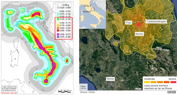
Figure 1: Official seismic hazard map of Italy and localization of recent seismic events
Classic Italian planning approaches as a reaction to these events have primarily considered at the core of the strategy the capability to rebuild local urban structures as much similar as before the damages caused by the natural event, according to the financial resources available. Considering that every 20 years ca. a strong seismic event occurs somewhere on the hotspots of the peninsula, there are high probabilities that those areas are going to never be back to thrive. Rather, in most cases, earthquakes and consequent common planning approaches are, historically, more likely to create new ghost towns, especially in Italian small-sized towns with ancient urban patterns and infrastructures.
Problematization
The society is experiencing the increasing awareness of the complexity of urban systems and
their vulnerability. Although community engagement is increasingly supported by the
evolution of technologies more accessible to a larger number of people, democratization of post-earthquake planning practices in the Italian context is still struggling to emerge and being included in the common practices. Given the fact that along with climate change trends, natural disasters such as earthquakes are becoming more frequent and more impacting on territorial systems, traditional approaches urgently need innovative and more comprehensive perspectives suitable for being translated into action-oriented processes. It is assumed that the methodological Geodesign approach could bring to the post-earthquake planning process some of the innovations acclaimed by researchers and practitioners, worldwide. Therefore, through a Geodesign project and workshop conducted on the Norcia municipality recently hit by a strong seismic event, it has been possible to test the approach’s potentials and to investigate whether it could answer to the scientific call.
Geodesign workshop: preparation and process
The Geodesign study started in January and ended in May 2017, with the organization of the workshop at the beginning of April. The project has been broken down into three main phases: [1] pre-workshop; [2] workshop and [3] post-workshop. In each phase, it has been answered to the Steinitz’s Geodesign models, accordingly to the theoretical framework.
In the pre-workshop phase, it has been set the boundary of the case study and analysed the main natural and urban characteristics (defined as systems) that distinguish the Norcia municipality from the surroundings, also taking into account the negative effects caused by the earthquake and consequent prioritized emergency interventions. Through GIS environment and geoprocessing elaborations, the study area has been spatially assessed following the ten territorial systems: Ecology, Agriculture, Public Spaces for Civil Protection, Historical and Cultural Tourism, Eco-Tourism, Commerce and Industry, Residential Development, Transport, Energy and Priority of Intervention. An objective has been set for each system.
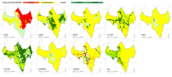
Figure 2: The Norcia territorial systems and their evaluation maps
In Figure 2, only nine out of ten systems have been represented, since the Priority of Intervention system was a blank map where participants could freely plan all type of strategies which had to be addressed in a short time period, basing on local knowledge and territorial physical information obtained by a series of base maps. Moreover, the Eco-Tourism evaluation map has been created by participants (during the workshop phase) thanks to the InViTo collaborative platform. The ten evaluation maps provided the common workspace and “language” that fostered the collaboration between all the local actors involved, opening up to the workshop phase.
The one and a half day workshop activated the engagement process, technically supported by the Geodesign hub (GDH) collaborative platform.
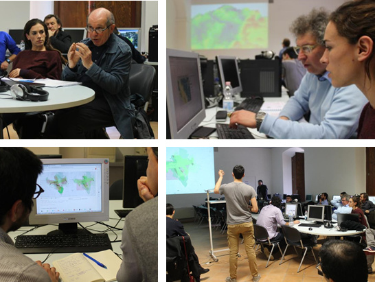
Figure 3: Collaborative interaction during the workshop
The participants such as technicians, academics and public authority (civil protection) as well as local entities and citizens, demonstrated an immediate comprehension of the GDH tool which through its facilitated user interface, sped up the collaborative process. It has been also noticed that the visual help of the hub, together with a consultable 3D model of the study area, avoided participants to go abstract during both discussion sessions in the design proposal stage and negotiation phases.
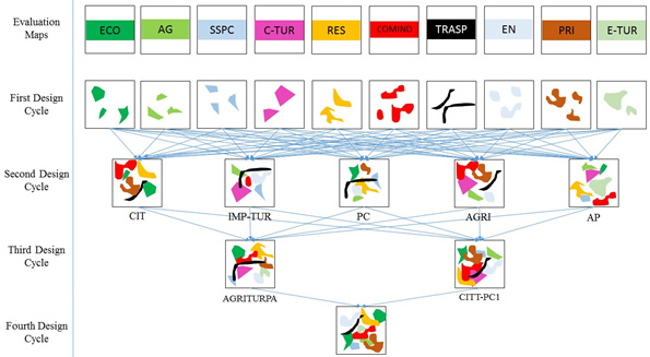
Figure 4: The workshop structure and the maximization of consensus
As summarized in Figure 4, the workshop phase was divided into 4 design cycles where participants initially started to work independently and, successively, been joined in 5 design groups with the task of selecting an overall strategy composed of both physical projects and policies. In the last design cycle, the groups were finally merged into a single heterogeneous group through a negotiation phase. As it can be observed from Figure 4, the process tangibly represents the concept of the maximization of consensus, where design and information created from the groups were in a way, translated into the last co-created strategy, the suggested plan. It was also really interesting to notice the participant’s response to the GD approach which simultaneously to the creation of the suggested rehabilitation plan for Norcia, generated soft output such as local territorial knowledge awareness and exchange, emphasizing the learning process coming out from the workshop.
Furtherly, the post-workshop phase has been put in place in order to disclose the workshop outcomes to a wider audience and obtain feedbacks from local people which would not be able to participate in the workshop, it has been used a GDH plug-in which enables the sharing of the final strategy through social media platform. By setting the voting system, people could accept and reject the strategies and design, influencing the suggested plan created during the workshop phase. Clearly, the prime meaning of the voting system was to obtain feedbacks from all the local actors and analyse the public response.
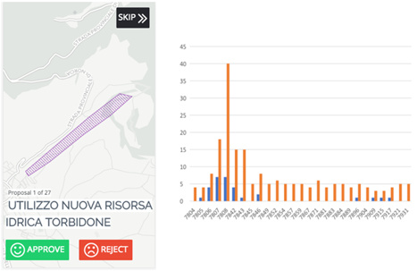
Figure 5: voting system interface and analysis graph
Outcomes
Through this project, it has been demonstrated that democratization of planning processes for the purpose of better inform the decision-making phase is highly attainable even in complex contexts as post-disaster scenarios. Common practices are still struggling to define the way for inclusion of participatory activities within an emergency. Time pressure and the economic perspective are still dominating the frame for action for rehabilitation interventions. We highly believe that after the happening of a natural event, the changed geographical conditions and the change in values and priorities for the local community should dominate the scene and be main drivers for determining the essence of the strategies for resilient development. Through analysing the hard and soft outcomes coming out from the workshop, we have recognized the acknowledged relevance of the Geodesign approach and the Geodesign hub tool to be applied to wicked contexts due to its ground-breaking key points and benefits such as:
- System thinking approach: integrated planning is fundamental for a more comprehensive territorial analysis of physical and not-physical (societal dynamics) conditions;
- Educational learning process: essentially, we took the participants on a journey from no plan to a collaborative plan. People engaged work with shared knowledge and create shared understandings of territorial challenges and opportunities. Moreover, the overall mutual trust and commitment are enhanced.
- Collaborative process: it allows the production of a hard digitalised outcome. Indeed, a record of the work is kept on the tool that can be referred. Being digital means that you get away from paper, tapes, and “things hanging on the wall”, often forgotten when working with scenarios.
- Time savings: the co-created early-stage strategy speeds up the rehabilitation process of a damaged area. Usually, the commonly believed urgency of taking fast action historically turned out to act as a planning retarder, slowing down the bureaucratic machine in re-activating an area which, in Italian post-earthquake contexts, often led to depopulation issues (Irpinia, L’Aquila; etc.). The plan also provides a clear visualized and editable time-frame for physical operation and policies implementations. This is an important aspect in order to create a continuum between prioritized short-term emergency measures and long-term redevelopment actions, making the locals understanding the direction taken.
- Economic savings: As an obvious consequence of time savings, the co-created plan can reduce the costs of outlining a rehabilitation plan, highlighting the possibility to differently allocate economic resources for prioritized activities, reactivating the local economic “engine”. The Castelluccio crops’ case could be a clear example from the case study where economic support was needed to maintain access and manpower to the crops which represents the local boost due to both production and tourism reasons.
Furtherly, it is interesting to mention that the Italian planning regulations in non-emergency contexts have already begun to provide room for collaborative approach and citizens engagement in planning procedures. According to the outcomes of the case study, a vast number of potentialities and benefits can be activated by expanding these approaches also to emergency contexts from a normative perspective.
Biographies
Francesco Fonzino, from Pistoia, Tuscany, Italy; Bachelor degree in Landscape architecture and urban planning obtained at the University of Florence (Italy).
Emil Lanfranchi, from Bergamo (Italy); Bachelor degree in Urban, Environmental and Landscape Geography at the University of Bologna (Italy).
We both recently have graduated with a master degree in engineering in Sustainable Cities, at the Aalborg University, Copenhagen (Denmark).
We have been involved in several Geodesign workshops in Italy and Poland and currently collaborating with the Federal University of Minas Gerais for the organization of the Geodesign Summit South America which will take place in Belo Horizonte on December 2017.
Acknowledgements
The authors would especially like to thank and express sincere appreciation to the Geodesign team who supported and mentored us throughout the project: Hrishikesh Ballal developer and owner of the Geodesign hub software, Professor Ana Clara Moura of the Federal University of Minas Gerais, Professor Michele Campagna of the University of Cagliari, Dr. Stefano Pensa of the Polytechnic of Turin, PhD Candidate Chiara Cocco of the University of Cagliari, MSc Pedro Casagrande of the Federal University of Minas Gerais and PhD Candidate Bruno de Andrade of the Federal University of Minas Gerais.
A special and grateful thank to Professor Jacob Norvig Larsen, the internal supervisor at the Aalborg University, for his constant help in guiding and help us in better shaping our thoughts and to the University of Perugia to have hosted the collaborative event.
References
Guo, Y. (2012). “Urban Resilience in Post-Disaster Reconstruction: Towards a Resilient Development in Sichuan, China.” Int. J. Disaster Risk Sci. 2012, 3 (1): 45–55
doi:10.1007/s13753-012-0006-2